Continental Divide Trail
- Miles: 3100
- State(s): NM,CO,WY,ID,MT
- Region(s): South West, West
Continental Divide Trail
CDT
New Mexico
Colorado
Wyoming
Idaho
Montana
National Scenic Trail
Description
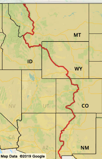
The Continental Divide Trail is a 3100 mile long trail that starts at the Mexican border and travels north
to the US/Canadian border. The CDT is designated a National Scenic Trail. The trail travels through the states of New Mexico,
Colorado, Wyoming, Idaho, and Montana, and also passes through 25 National Forests, 21 Wilderness Areas, 3 National Parks, including
Rocky Mountain National Park, Yellowstone National Park, and Glacier National Park.
Guidebooks and Map
Continental Divide Trail Coalition - CDT Planning Guide
Yogis CDT Handbook
CDT Maps
Phlumf CDT Maps
Postholer CDT Maps
Postholer CDT Databook Online
Trail Organizations
US Forest Service - CDT
Continental Divide Trail Coalition
Continental Divide Trail Coalition on Facebook
Continental Divide Trail Society
Other Resources
Guthook CDT App - Cell Phone App with maps and waypoints