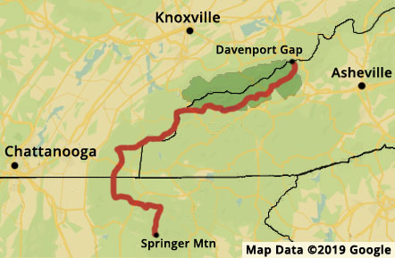
The Benton MacKaye Trail starts at Springer Mountain in Georgia and travels north to Davenport Gap in the northeastern corner of Great Smoky Mountains National Park. The trail is almost 300 miles in length and meets the Appalachian Trail three times. The BMT shares the southern terminus at Springer Mountain and coaligns with the AT for several miles before turning west through the Chattahoochee National Forest. The BMT also meets the AT at Fontana Dam and at the BMT northern terminus, Davenport Gap in the Smoky Mountains, making a figure eight with the AT. The trail passes through several wilderness areas while traversing Georgia, Tennessee, and North Carolina.